I ran across an interesting dilemma during a rural ride the other day that highlights one of the problems with mapping in Thailand, a country that has an alphabet and language as unlike English as any you're likely to encounter, and whose rural inhabitants seldom use route numbers or even maps for that matter. Being an American, a map lover, and something of a detail freak I want the work I do and the descriptors ("tags" in OSM parlance) of the data I gather to be accurate regardless of whether or not Thais use those route numbers. This means that issues like the one I'm about to describe drive me crazy.
For some reason I enjoy adding mile marker locations to the OSM (Open Street Map) of Thailand. I've even developed a "tagging preset" for use inside the JOSM editor (an OSM map editor) that allows me to add data about them in a consistent manner. Maybe this fascination comes from my earlier use of USGS Topographical maps which had carefully located
benchmarks inscribed on the maps of my favorite haunt in those days, New York State's Adirondack Mountains. We don't see such markers very often in the states but here in Thailand they're fairly common and I enjoy discovering and mapping them, especially when they add or correct information about route numbers in the OSM.
.jpg) |
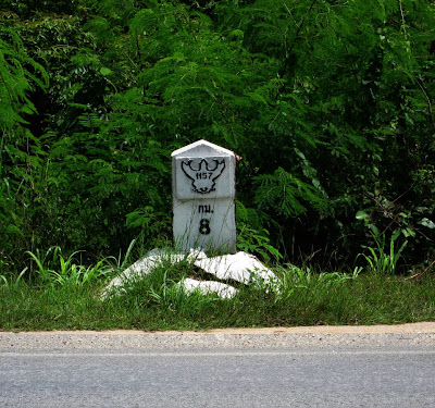
| Mile marker — Thailand R 1157 |
At any rate, we were driving on Thailand 1157 north of Lampang. I was taking photos of various points of interest for addition to the OSM later when I spotted a concrete mile marker on an intersecting road. I pulled over to snap a photo. To my surprise there was not one but two mile markers, one on either side of the pavement, and they designated the highway with two different route numbers.
 |
| Rural road: ลป 4010 |
|
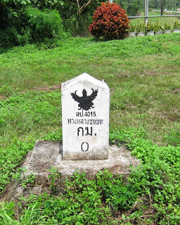 |
| Rural road: ลป 4015 |
|
|
I recently learned from some other mappers that Thailand has been changing route numbers on its road system for some time and I apparently happened upon one of those changes that is either in process and not completed or just plain forgotten about. Notice that the marker for ลป 4010 seems to be newer. Well, there was also a nice, new, unambiguous sign directly in front of the ลป 4010 marker that designates the highway as ลป 4015. Thus the highway is tagged as a tertiary highway with the designation ลป 4015.

As an aside FYI, the notation ลป 4010 implies (Rural Highway) Lampang 4010 where the "ลป" is an approximate abbreviation for Lampang, the province within which the road lies. The intersection is in the center of this OSM screen:
intersection 1157 and ลป 4015. You may also view it in Google Earth by plugging in these coordinates: N18.47403 E99.46708. The prefix ชม (for CM) appears on all rural highways in Chiang Mai Province.
There are many cases in which it is virtually impossible to transliterate Thai into English and vice-versa. The repercussions of this fact permeate all mapping, all reading actually, in Thailand. Here's an example. The small city I live in, Chang Phuak, is a suburb of Chiang Mai whose name can be spelled several ways. In Thai it is ช้างเผือก. (Note the absence of spaces.) Transliterating first syllable is fairly straightforward: the ช้ represents a sound we can approximate with "ch", the ง with "ng" while the า is a vowel marker that indicates an "ah" sound which produces the English equivalent chang. The two syllables (เผือก) comprising the second part are tricky and illustrates what I'm talking about. The character ผ would translate as a "pah" sound if it were unmodified. But it is not. The little "hat" which, along with the "เ", is a Thai vowel marker and represents a sound we simply do not have in English. Not even close. I can (very) roughly approximate it by using the phoneme "eiuuw" as when a teenager expresses dislike for something icky.
As if that isn't bad enough, there is a common convention when transliterating Thai to English that places an "h" after certain consonants to indicate a hard sound. The Ph in Phuak indicates that the "p" is sounded plosively, like the "p" in pound. If pronounced with a soft "ph" as in philosophy it would be incorrect. So, after all that we end up with p-eiuuw-ak! How does one represent that sound in English?
Consequently there are many ways to spell Chang Phuak: Chang Phuak, Chang Phuek, Chang Phueak, Chang Puak, and variations. In addition, there are no spaces between Thai words (ช้างเผือก) so another Thai-like spelling has it Changphuak, etc. Anyway, the upshot of all this is that if you're a speaker of English searching for a place name in Thailand, for example on your GPS receiver, you're probably not going to find it. And Google Translate, so efficient at translating German, French and Spanish, absolutely mangles even the simplest Thai. Would-be mappers surely have their work cut out for them.
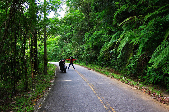
Here's another story involving mile markers. We took a wonderful ride to the east the other day to the Kiew Ko Ma Reservoir over some small but scenic rural roads. I had earlier added the reservoir to OSM by tediously tracing the Bing imagery using over 4,000 points for its amoeba-like outline and wanted to see it in the flesh, so to speak. We first drove to Doi Saket and then took rural route ชม 4074 over the spine of the Khun Tan mountain range (GE screen shot below) whereupon we entered the province of Lampang. It's slow going on the narrow, curvy road but there are waterfalls aplenty and the forest is cool, dark, and beautiful.
 |
| Chiang Mai Rural Route ชม 4074 |
 |
| Nut and the CB500X on ลป 4329 |
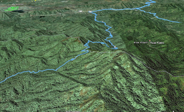 |
Google Earth view SW toward Chiang Mai over the 4879 ft pass
Our GPS track is in blue - highest peak about 6000 ft |
After the pass, the road continues but there are no route signs. Someone early on designated this highway ลป 4329, then changed it to unclassified. I changed it back but now am having second thoughts. Although paved for its entire length, this is a truly rural road — there are several places where it fords streams! — but it is unmarked. Designating it with that number would be pure guesswork on my part.
 |
| Lampang Rural Route ลป 4329 (or not?) |
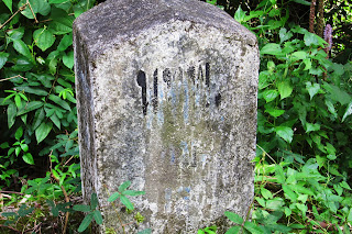
We did eventually see a few ancient mile markers but the lettering on them was mostly unreadable and offered no clue as to the designation of the road. The marker below, left is typical of what we saw. However, the one on the right has the Thai characters
รพช (in English: RPC) embossed in the cement.
 |
| Unreadable mile marker |
|
 |
| รพช marker |
|
|
Nut made a few calls to relatives and from them we learned this stands for
Rengrat Pattana Chonabot, (เร่งรัดพัฒนาชนบท) and designates rural projects that were instigated
by the king for the benefit of the local people during a 1960s push for rapid
rural development, in general called pattana chonabot. The roads were never intended to be high speed thoroughfares but rather to provide basic infrastructure to help Thailand become more competitive in the global marketplace. Another area that was impacted by royal projects in this vein is irrigation. Rice is a very thirsty crop, so Thailand has literally thousands of dams, reservoirs and power projects. Maybe the Kiew Ko Ma Dam is part of a
pattana chonabat imperative?
.jpg) |
| Nut astride the CB500X at the Kiew Ko Ma Dam |
We visited the reservoir and drove home on Thailand Route 1252, a sorry excuse for a major highway. The pavement is good in spots, broken and potholed in others. But again, the reward was in the scenery. Here is a shot looking northwest as the sun was going low in the sky.
.jpg) |
| View from R 1252 near dusk |
Addenda:
GPX files of these trips :
Lampang Loop |
Kiew Ko Ma Reservoir
Right click on the file link and select Save As from the menu that appears, browse to a folder or your desktop to download the file(s). You can open them with Google Earth or any other application that can read GPX files.
The Thai phrase เร่งรัด พัฒนา ชนบท literally means "rapid rural development". It's abbreviated
รพช as discussed above. I inserted the spaces for easier reading ;-)
OSM map of
Kiew Ko Ma Reservoir (opens in your browser)
<presets xmlns="http://josm.openstreetmap.de/tagging-preset-1.0">
<item name="Milemarker" type="node">
<label text="Tagging for a Milestone" />
<text key="description:en" text="Description" default="Kilometer Zero Milestone" delete_if_empty="true" />
<key key="highway" value="milestone" />
<text key="ref" text="ref" default="" delete_if_empty="true" />
<text key="distance" text="Distance" default="" delete_if_empty="true" />
<text key="inscription:en" text="Inscription" default="" delete_if_empty="true" />
<text key="inscription:th" text="(Thai?) " default="" delete_if_empty="true" />
<key key="source" value="GPS;geolocated photo;Bing" />
</item>
</presets>

.jpg)
+(sm).jpg)
.jpg)
.jpg)
.jpg)
).jpg)
.jpg)


.jpg)


.jpg)
.jpg)