I recently posted a few of the photos that appear in this post on Facebook but I wanted to include them here as part of a story of how they came to be. Then too, they can be viewed in a larger size and higher quality here than on Facebook, which compresses them severely to fit on its Timeline.
Most of these were taken a couple of weeks ago on what turned out to be a longish ride to a hilltop temple. Nut enjoys visiting temples she's heard about but never had a chance to visit. Often she'll say to me from the "back seat" as we pass a sign about a Wat Something-Or-Other, "Oh, that's the road to Wat Something-Or-Other. I've always wanted to see that one. Can we go?"
Now, I will admit that my first thought is often, what, another temple? But before that thought is vocalized and knowing that she has led me to other sights and scenes I wouldn't have enjoyed otherwise, I usually say, "Sure, honey. Let's take a look." That's how we ended up at the temple with the almost unpronounceable name of Wat Phrabhuthabat Si Roi. (prah-boo-ta-baat'-see-roy) We were on our way home from a coffee ride, driving along Route 3009 (I blogged about that road earlier
here), when she pointed to a small concrete lane off to the right, a road that went west and up, and up, and then up some more, to the temple that was situated, as are many of these wats, near the top of a heavily wooded mountain. (The Wat is at 1000 m. or 3400 ft above sea level — coordinates: N19.01658 E98.76222). It was cool and cloudy and the thick jungle had trapped some mist at the higher altitudes which lent a somewhat ominous look to the narrow lane that day. Throw in a few hairpin turns with near 20% grades and I found myself driving with all my senses focused on the narrow road ahead. I ogled the scenery afterward, on the way back down ;-)
It was well worth the side trip because this wat is spectacular! Not surprisingly, people drive long distances and come from all over Thailand to see it. We chatted with a woman and her daughter who had flown from Bangkok, rented a car, and then drove the 50 or so kilometers from their Chiang Mai hotel just to see this wat.
.jpg) |
| The Wat Phrabhuthabat Si Roi |
.jpg) |
| Ceiling detail |
As with all photographs in this blog, you may click on them to open in a new window where they will display in a much larger size.
We looked around for quite a while taking pictures and making notes for the mapping I would inevitably do back at home. By the time we left it was starting to get dark. I lingered along the road back to get some pictures in the fading light. The clouds were gorgeous and the sun was setting, ideal conditions for some dramatic photos. The road is lined with rain forest and jungle except for a few spots that open out onto the nicely tended farm fields and orchards which you see below.
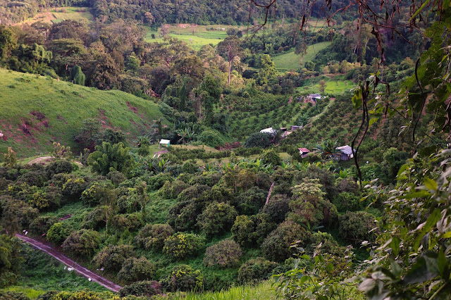 |
| Farm and orchards |
 |
| View east toward Ping River Valley from an elevation of 2500 ft |
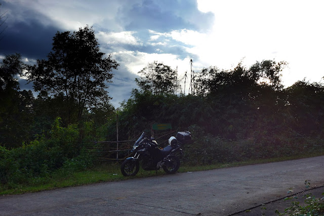 |
| The CB500X on the road to the Wat |
 |
| Farms in the jungle |
 |
| Another view east to the Ping River Valley |
 |
| My favorite - the Ping River Valley again |
The following are from another visit to the same Wat. We took our friend and neighbor, Daniel, along for the ride this time. Again, on the way home and just before the sun dropped behind the mountains I got this nice shot.
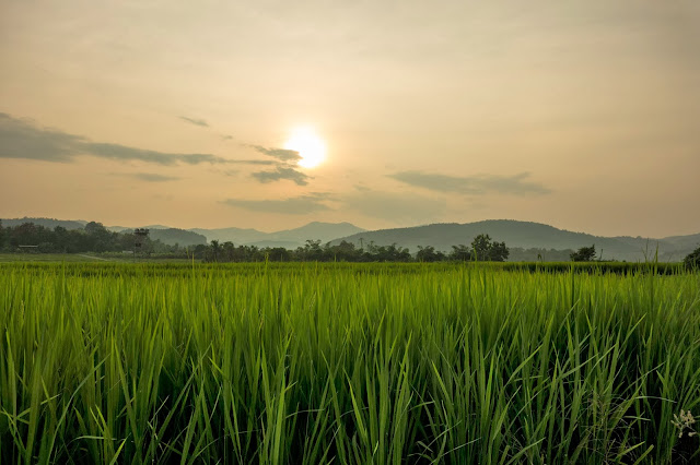 |
| Rice and sun - Ping River Valley |
Here's Nut and Daniel patiently waiting for me to finish up my photographic shenanigans.
Addenda:
GPX file :
Route 3009 and the road to the Wathe road to the Wat
Click on the file link and select Download from beneath the cleverly hidden "More" menu (those three blue dots), at the top right of the resulting page, browse to a folder or your desktop where you want to place the file and click on the Save button. You can open them with Google Earth or any other application that can display GPX files.
Here's a screenshot to help you locate the area we visited. The actual road to the wat is only about 12 miles in length but seems a lot longer because it's so narrow and curvy:
.jpg)
+(sm).jpg)
.jpg)
.jpg)
.jpg)
).jpg)
.jpg)


