Friday, December 6, 2013

Motorcycling in northern Thailand - Mae Hong Son Loop

We've been doing a bit of traveling during the past few weeks. The weather is sublime, the roads beckoning to be driven, the scenery begging for oohs and aahs from those lucky enough to be seeing it from the seat of a motorcycle. The dry season is well under way now and this beautiful part of the world is at it's prime.

Nut and I wanted to revisit a well known national park, Thung Bua Tong, southwest of here to see the gorgeous sunflower fields while the blooms were at their peak. We just missed them when we visited there in 2011, arriving after most of the flowers were finished. We decided to ride the famous Mae Hong Son loop as long as we were over that way. We did this trip with an American expat couple we met a few months ago, Bruce and Kathleen. They ride a big Honda Forza, a 300cc automatic cruiser that looks a bit like a scooter on steroids. Its huge seat makes riding 2-up easy and comfy.

We made the 600 km circuit in clockwise fashion: Chiangmai to Mae Hong Son to Pai and back to Chiangmai. The first leg took us from Chiang Mai to Doi Inthanaon and Mae Chaem where we stopped for lunch. The ride up and over Doi Inthanon's spine is always fun and up at that altitude, always cool. We turned off onto the 1192 just before the summit. If you click on the photo below to view it full size you can see the royal pagodas near Inthanon's 8,000 ft summit, the highest in Thailand. Also just discernible in the lower left is Mae Pan Waterfall.

View north to Doi Inthanon from R 1192
The highways beyond Mae Chaem, the 1088 north and the 1263 west to Khun Yuam, are choppy and in some places severely potholed. Although the surroundings are beautiful I couldn't really take my eyes off the road. That's the one drawback about motorcycle touring. It's a bad idea to allow yourself to be distracted in any way, scenery or whatever, and when the roads are bad it's even more important to keep completely focused.

We overnighted in Khun Yuam at a place that's been around for many years, the Ban Farang Guesthouse. The accommodations were adequate but the bungalows tiny with barely enough room for the bed and a TV stand. There are several new guesthouses being built and once they're up and running the choice of hotels will be improved significantly. After a fantastic, farang style breakfast and excellent lattes at the Peekmail Restaurant on R 108 just south of the town center, we were off to see the sunflowers.

Sunflower fields at Thung Bua Tong National Park


Bruce and Kathleen and their Forza
We took a short ride up the มส 4009 beyond the park and I was again struck by the beauty of Thailand's rice fields. Late November is harvest time for rice. The harvesting is still mostly done by hand and we saw many fields with people wielding short hand scythes or gathering sheaves of cut rice stalks which were then carried to the roadside. In some fields we saw workers hand threshing the rice from the stalks by beating the sheaves on a collection mat. It must be hot, dusty work.


Rural homestead - Route มส 4009
On the way back we stopped at an overlook that offered a view of the sunflowers and mountains to the south that I just had to grab.


After gawking at the flower studded hills we headed back to Khun Yuam to pick up the 108 for the short hop north to Mae Hong Son. I drove this stretch of highway years ago during my first visit to Thailand but had forgotten how beautiful it was and what great motorcycling it offered. We cruised right along through the jaw dropping scenery only stopping for coffee about midway, and for this quick snapshot of the heavily forested mountains east of the highway.


The tourist season is underway presently and accommodations in Mae Hong Son were spotty. We hunted around for a while looking for an affordable room (i.e., under $25/night) and ended up staying at a resort that was adequate but nothing special. Of course I was busy in the evenings adding details to the OSM map of northern Thailand. Although this town and Pai, our next stop, are immensely popular tourist destinations there is no aerial imagery coverage with which to help sketch in their roads and residential streets. If I wanted to expand the map I would have to drive every street in town with GPS and camera. I was planning to do that but after a full day on the bike just couldn't summon up the energy. Some other day maybe.

Next day we were off early on our way to Pai. Again, I had quite forgotten how spectacular the mountain scenery is along this stretch of the loop.
The road just traveled - below us the 1095 winds its way upward
Another beautiful day with my beautiful girl

Bruce & Kathleen
 We arrived in Pai towards afternoon and were lucky to get two bungalows at my favorite guesthouse there, Ta Yai. We had time to visit Pai Canyon and the Chinese village west of the town, where we also ate dinner. Pai was crowded with tourists, both Thai and farangs. I made one solo mapping run and was impressed by the sheer number of guest houses, resorts and cafes lining every highway and byway. Even a few short years ago, it was hard to find a decent coffee shop that served quality espressos. Now, they're literally everywhere up north, and not only in Pai. Thailand has a burgeoning coffee growing industry and the delicious, mountain-grown Arabica is driving the spread of these cafes.

At the "Chinese Village" outside of Pai
Next day we were off to Chiang Mai. Although this section of the loop is also very scenic, it's heavily used during the tourist season and that makes it not as much fun. The road is bumpy and has some hellacious switchbacks to negotiate. Numerous mini-vans and other tourist traffic, not to mention hordes of crazy motorcyclists day tripping out of Chiang Mai, increase the risk of an accident. I was glad to leave the hills behind as we jetted along to Pankred Coffee where we lunched and coffee-ed up for the rest of the ride home on the mellow 3009.

Thus ended another fantastic ride in Thailand's Lanna Kingdom.


Addenda:

GPX files :
Day 1 - Chiang Mai to Khun Yuam - 1009, 1152, 1088, 1263
(Note: We had to double back on the 1263 for a short distance to visit the park before going north to Mae Hong Son. I've included two gpx files below, one with the side trip, the other is the direct route to Mae Hong Son along R 108.)
Day 2 - Khun Yuam to Mae Hong Son (direct) - Route 108
Day 2 - Khun Yuam to Mae Hong Son plus Thung Bua Tong sidetrip
Day 3 - Mae Hong Son to Pai - R 1095
Day 4 - Pai to Chiang Mai - R 1095, 3009

Click on the file link and select Download from beneath the cleverly hidden "More" menu (those three blue dots), at the top right of the resulting page, browse to a folder or your desktop where you want to place the file and click on the Save button. You can open them with Google Earth or any other application that can display GPX files.

Tuesday, October 22, 2013

Recent photographs : Wat Phrabhuthabat Si Roi

I recently posted a few of the photos that appear in this post on Facebook but I wanted to include them here as part of a story of how they came to be. Then too, they can be viewed in a larger size and higher quality here than on Facebook, which compresses them severely to fit on its Timeline.

Most of these were taken a couple of weeks ago on what turned out to be a longish ride to a hilltop temple. Nut enjoys visiting temples she's heard about but never had a chance to visit. Often she'll say to me from the "back seat" as we pass a sign about a Wat Something-Or-Other, "Oh, that's the road to Wat Something-Or-Other. I've always wanted to see that one. Can we go?"

Now, I will admit that my first thought is often, what, another temple? But before that thought is vocalized and knowing that she has led me to other sights and scenes I wouldn't have enjoyed otherwise, I usually say, "Sure, honey. Let's take a look." That's how we ended up at the temple with the almost unpronounceable name of Wat Phrabhuthabat Si Roi. (prah-boo-ta-baat'-see-roy) We were on our way home from a coffee ride, driving along Route 3009 (I blogged about that road earlier here), when she pointed to a small concrete lane off to the right, a road that went west and up, and up, and then up some more, to the temple that was situated, as are many of these wats, near the top of a heavily wooded mountain. (The Wat is at 1000 m. or 3400 ft above sea level — coordinates: N19.01658 E98.76222). It was cool and cloudy and the thick jungle had trapped some mist at the higher altitudes which lent a somewhat ominous look to the narrow lane that day. Throw in a few hairpin turns with near 20% grades and I found myself driving with all my senses focused on the narrow road ahead. I ogled the scenery afterward, on the way back down ;-)

It was well worth the side trip because this wat is spectacular! Not surprisingly, people drive long distances and come from all over Thailand to see it. We chatted with a woman and her daughter who had flown from Bangkok, rented a car, and then drove the 50 or so kilometers from their Chiang Mai hotel just to see this wat.

The Wat Phrabhuthabat Si Roi

Ceiling detail


As with all photographs in this blog, you may click on them to open in a new window where they will display in a much larger size.

We looked around for quite a while taking pictures and making notes for the mapping I would inevitably do back at home. By the time we left it was starting to get dark. I lingered along the road back to get some pictures in the fading light. The clouds were gorgeous and the sun was setting, ideal conditions for some dramatic photos. The road is lined with rain forest and jungle except for a few spots that open out onto the nicely tended farm fields and orchards which you see below.

Farm and orchards

View east toward Ping River Valley from an elevation of 2500 ft

The CB500X on the road to the Wat
Farms in the jungle
Another view east to the Ping River Valley
My favorite - the Ping River Valley again
The following are from another visit to the same Wat. We took our friend and neighbor, Daniel, along for the ride this time. Again, on the way home and just before the sun dropped behind the mountains I got this nice shot.

Rice and sun - Ping River Valley
Here's Nut and Daniel patiently waiting for me to finish up my photographic shenanigans.


Addenda:

GPX file : Route 3009 and the road to the Wathe road to the Wat

Click on the file link and select Download from beneath the cleverly hidden "More" menu (those three blue dots), at the top right of the resulting page, browse to a folder or your desktop where you want to place the file and click on the Save button. You can open them with Google Earth or any other application that can display GPX files.

Here's a screenshot to help you locate the area we visited. The actual road to the wat is only about 12 miles in length but seems a lot longer because it's so narrow and curvy:


Thursday, October 10, 2013

OSM Mapping in Thailand

I ran across an interesting dilemma during a rural ride the other day that highlights one of the problems with mapping in Thailand, a country that has an alphabet and language as unlike English as any you're likely to encounter, and whose rural inhabitants seldom use route numbers or even maps for that matter. Being an American, a map lover, and something of a detail freak I want the work I do and the descriptors ("tags" in OSM parlance) of the data I gather to be accurate regardless of whether or not Thais use those route numbers. This means that issues like the one I'm about to describe drive me crazy.

For some reason I enjoy adding mile marker locations to the OSM (Open Street Map) of Thailand. I've even developed a "tagging preset" for use inside the JOSM editor (an OSM map editor) that allows me to add data about them in a consistent manner. Maybe this fascination comes from my earlier use of USGS Topographical maps which had carefully located benchmarks inscribed on the maps of my favorite haunt in those days, New York State's Adirondack Mountains. We don't see such markers very often in the states but here in Thailand they're fairly common and I enjoy discovering and mapping them, especially when they add or correct information about route numbers in the OSM.
Mile marker — Thailand R 1157
At any rate, we were driving on Thailand 1157 north of Lampang. I was taking photos of various points of interest for addition to the OSM later when I spotted a concrete mile marker on an intersecting road. I pulled over to snap a photo. To my surprise there was not one but two mile markers, one on either side of the pavement, and they designated the highway with two different route numbers.
Rural road: ลป 4010
Rural road: ลป 4015
I recently learned from some other mappers that Thailand has been changing route numbers on its road system for some time and I apparently happened upon one of those changes that is either in process and not completed or just plain forgotten about. Notice that the marker for ลป 4010 seems to be newer. Well, there was also a nice, new, unambiguous sign directly in front of the ลป 4010 marker that designates the highway as ลป 4015. Thus the highway is tagged as a tertiary highway with the designation ลป 4015.


As an aside FYI, the notation ลป 4010 implies (Rural Highway) Lampang 4010 where the "ลป" is an approximate abbreviation for Lampang,  the province within which the road lies. The intersection is in the center of this OSM screen: intersection 1157 and ลป 4015. You may also view it in Google Earth by plugging in these coordinates: N18.47403 E99.46708. The prefix ชม (for CM) appears on all rural highways in Chiang Mai Province.

There are many cases in which it is virtually impossible to transliterate Thai into English and vice-versa. The repercussions of this fact permeate all mapping, all reading actually, in Thailand. Here's an example. The small city I live in, Chang Phuak, is a suburb of Chiang Mai whose name can be spelled several ways. In Thai it is ช้างเผือก. (Note the absence of spaces.) Transliterating first syllable is fairly straightforward: the ช้ represents a sound we can approximate with "ch", the ง with "ng" while the า is a vowel marker that indicates an "ah" sound which produces the English equivalent chang. The two syllables (เผือก) comprising the second part are tricky and illustrates what I'm talking about. The character ผ would translate as a "pah" sound if it were unmodified. But it is not. The little "hat" which, along with the "เ", is a Thai vowel marker and represents a sound we simply do not have in English. Not even close. I can (very) roughly approximate it by using the phoneme "eiuuw" as when a teenager expresses dislike for something icky.

As if that isn't bad enough, there is a common convention when transliterating Thai to English that places an "h" after certain consonants to indicate a hard sound. The Ph in Phuak indicates that the "p" is sounded plosively, like the "p" in pound. If pronounced with a soft "ph" as in philosophy it would be incorrect. So, after all that we end up with p-eiuuw-ak! How does one represent that sound in English?

Consequently there are many ways to spell Chang Phuak: Chang Phuak, Chang Phuek, Chang Phueak, Chang Puak, and variations. In addition, there are no spaces between Thai words (ช้างเผือก) so another Thai-like spelling has it Changphuak, etc. Anyway, the upshot of all this is that if you're a speaker of English searching for a place name in Thailand, for example on your GPS receiver, you're probably not going to find it. And Google Translate, so efficient at translating German, French and Spanish, absolutely mangles even the simplest Thai. Would-be mappers surely have their work cut out for them.

Here's another story involving mile markers. We took a wonderful ride to the east the other day to the Kiew Ko Ma Reservoir over some small but scenic rural roads. I had earlier added the reservoir to OSM by tediously tracing the Bing imagery using over 4,000 points for its amoeba-like outline and wanted to see it in the flesh, so to speak. We first drove to Doi Saket and then took rural route ชม 4074 over the spine of the Khun Tan mountain range (GE screen shot below) whereupon we entered the province of Lampang. It's slow going on the narrow, curvy road but there are waterfalls aplenty and the forest is cool, dark, and beautiful.

Chiang Mai Rural Route ชม 4074
Nut and the CB500X on ลป 4329
Google Earth view SW toward Chiang Mai over the 4879 ft pass
Our GPS track is in blue - highest peak about 6000 ft
After the pass, the road continues but there are no route signs. Someone early on designated this highway ลป 4329, then changed it to unclassified. I changed it back but now am having second thoughts. Although paved for its entire length, this is a truly rural road — there are several places where it fords streams! — but it is unmarked. Designating it with that number would be pure guesswork on my part.

Lampang Rural Route ลป 4329 (or not?)
We did eventually see a few ancient mile markers but the lettering on them was mostly unreadable and offered no clue as to the designation of the road. The marker below, left is  typical of what we saw. However, the one on the right has the Thai characters รพช (in English: RPC) embossed in the cement.
Unreadable mile marker
รพช marker
Nut made a few calls to relatives and from them we learned this stands for Rengrat Pattana Chonabot, (เร่งรัดพัฒนาชนบท) and designates rural projects that were instigated by the king for the benefit of the local people during a 1960s push for rapid rural development, in general called pattana chonabot. The roads were never intended to be high speed thoroughfares but rather to provide basic infrastructure to help Thailand become more competitive in the global marketplace. Another area that was impacted by royal projects in this vein is irrigation. Rice is a very thirsty crop, so Thailand has literally thousands of dams, reservoirs and power projects. Maybe the Kiew Ko Ma Dam is part of a pattana chonabat imperative?

Nut astride the CB500X at the Kiew Ko Ma Dam
We visited the reservoir and drove home on Thailand Route 1252, a sorry excuse for a major highway. The pavement is good in spots, broken and potholed in others. But again, the reward was in the scenery. Here is a shot looking northwest as the sun was going low in the sky.

View from R 1252 near dusk


Addenda:

GPX files of these trips : Lampang Loop | Kiew Ko Ma Reservoir

Right click on the file link and select Save As from the menu that appears, browse to a folder or your desktop to download the file(s). You can open them with Google Earth or any other application that can read GPX files.

The Thai phrase เร่งรัด พัฒนา ชนบท literally means "rapid rural development". It's abbreviated รพช as discussed above. I inserted the spaces for easier reading ;-)

OSM map of Kiew Ko Ma Reservoir (opens in your browser)


<presets xmlns="http://josm.openstreetmap.de/tagging-preset-1.0">
  <item name="Milemarker" type="node">
    <label text="Tagging for a Milestone" />
   <text key="description:en" text="Description" default="Kilometer Zero Milestone" delete_if_empty="true" />
    <key key="highway" value="milestone" />
    <text key="ref" text="ref" default="" delete_if_empty="true"  />
   <text key="distance" text="Distance" default="" delete_if_empty="true" />
   <text key="inscription:en" text="Inscription" default="" delete_if_empty="true" />
   <text key="inscription:th" text="(Thai?) " default="" delete_if_empty="true" />
    <key key="source" value="GPS;geolocated photo;Bing" />
  </item>
</presets>

Wednesday, September 25, 2013

Riding the Honda CB500X

September 24, 2013 — Chiang Mai, Thailand

Today is my 70th birthday and I'm glad to report that my life is going well. The heart surgery is in the past and the future is looking rosy from my vantage point here in northern Thailand. I'm busy, counting myself lucky to be alive and in such good health, riding my new motorcycle, and enjoying Thailand and my lovely friend and companion, Nut. I look back at the years leading up to this birthday and know I could never have planned for my life to turn out this way. Happy Birthday to me!

I've been trying to write this post for a few days but, as always, the OSM mapping projects I so enjoy consume most of my desk time. I've been working & riding in the area north of Lampang lately.  A look at the existing OSM of that region convinced me that there was a lot of exploring, and mapping work, to be done over there. We've made two day trips in the past couple of weeks and they were lots of fun, especially because the new bike is so awesome. More on mapping in later posts. This one is about the bike...

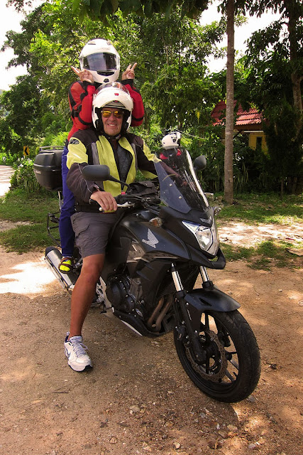
Me and Nut aboard the CB500X
The CB500X is an absolute dream. Regular readers know I loved my last bike, a 2011 Honda CBR250 that I drove 12,000 miles over the past two years, but this one is the bomb. Bigger and much more powerful, it makes driving these roads sheer pleasure, especially for a bloke my size and weight riding 2-up with my petite 110 lb girlfriend.  I can cruise along at 3 or 4 thousand RPM and when I twist the throttle, it gets up and goes. As an added bonus, it gets very respectable gas mileage. I'm running gasohol over here because it's quite a bit cheaper than gasoline ($4.60/gallon vs $5.40/gallon) and I've been getting roughly 70-75 mpg (30-32 km/liter). Not bad considering the CBR250 under generally similar conditions achieved an overall average of 78 mpg for the two years I drove it.

Mileage chart - CB500X
The CB500 isn't a superbike by any means but there is no comparison between the high-revving, single-cylinder CBR and this bike. It runs smoothly at 2500 RPM in the upper gears, a level at which the CBR's engine would shake, rattle and balk unless you were in 1st or 2nd. If I want to overtake a slow moving vehicle I often don't need to downshift - 6th gear has enough torque to pull it off. The roads here make for some gorgeous motorcycling but one doesn't need the sheer horsepower required for freeway travel in the states. I usually travel at around 50-55 mph, an absolutely pokey pace compared to the normal speeds I maintained in the U.S. on the VStrom a couple of years ago. The other thing is that while the roads in Thailand are fairly decent, they aren't billiard table smooth like those stateside. Most of them are concrete and were paved the old fashioned way, by hand, and a bunch of guys with trowels simply cannot produce as smooth a surface as our fancy paving machines. Consequently, even the best roads in Thailand are a bit lumpy — traveling at 70 mph makes for a fairly jittery ride on most highways.


The biggest plus for me is the increased comfort the larger bike provides. The CB500X is the touring model and as such, allows a very upright posture. The long-travel front forks suck up the bumps very well and the rear shock is set perfectly for riding 2-up; it's a much nicer all around ride than we're used to. The seat is higher then the CBR and the entire bike is scaled up to where I can ride all day with no wrist fatigue. The stock seat is fairly comfortable too. Nut, who has on occasion been heard to utter the Thai phrase, เจ็บตูด jep dtùut (butt hurts), after rides on my other bikes, hasn't complained about this one (yet).

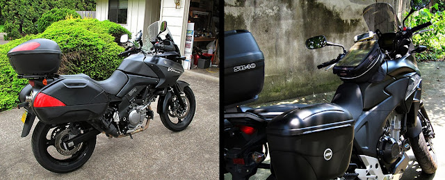
As I was browsing through my images I came across some I had from when I put my 650 cc VStrom up for sale back in 2011. I was struck by their similarities. Both are in matte black, both are mid-size twins, and both extremely comfortable for long distance riding. I recall when I was selling that bike after a lovely but frustrating (and cold) tour through the southwestern states that if not for the hefty import duties it would be a wonderful bike for Thailand. Fast forward and I now have almost the same bike except this one is lighter and quicker in traffic and through the turns.


I bought Givi (knock-offs) side cases so that when we tour we can take along enough gear to be comfortable. An added plus is that all the cases are lockable and lock to their mounts. I paid about $300 USD for them and a pair of extra loud PIAA horns, installed at CNX Motosport in Nong Hoi. (N18.75368 E99.00870). I had the guys at CNX mount the Shad top box I bought in Bangkok using a bracket made for the CB500 series that they also carry at their shop. We'd be lost without that top box. We use it to carry groceries and for safekeeping valuables while we're restauranting or shopping. All the boxes are waterproof too.
CB500 dash with my Garmin Montana in its mount
The bike is powered by a smooth and lusty sounding DOHC 4-valve per cylinder, water cooled, 471cc parallel-twin engine. Either this 6-speed transmission shifts extra well or my handling of the clutch has improved radically over the past couple of years because this baby shifts sweeter than any bike I've ever driven. Honda did a great job with the CB500's stock exhaust as well because it produces a very mellow tone at all RPMs. I always get a kick out of the CBR250 owners willing to shell out 4 or 5 hundred bucks for a fancy carbon-fibre muffler in the forlorn hope that it'll make the little powerplant sound more like a big bike. (And here I am bragging up the sound of my 500cc. Boys and their toys - it never changes. LOL)

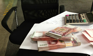
What 215,000 baht looks like
The CB500X sells in Chiang Mai for 215K baht ($6,900 USD) with ABS. Apparently the ABS on this bike isn't the same as the "combined ABS" I had on the CBR but I hope I never need to learn the differences. It was fitted with Pirelli Scorpion radial tires rather than the more common IRCs. Both are 17 inch wheels: rear 160/60, front 120/70.  (See my Notes below for more about tires.) The generous 4.5 gallon (17 liter) tank will get you 320-340 miles before filling up. Its speedometer, like all bikes I've tested, reads on the high side according to my GPS. This one is only 5% high whereas several Phantoms I've tested, my CBR250, my Suzuki VStrom all were off by +10%. That is, when the CB500X speedo reads 84 kph, you're really only going 80 kph. The odometer, on the other hand is fairly accurate. Go figure.

On the day I picked the bike up from Honda Big Wing the sales guy mentioned that he had a taller windscreen available for 1,500 baht ($45 USD), and did I want the last one in stock? Recalling the wind noise that plagued me on the VStrom tour I jumped at it. It was a great buy because with it the wind noise is quite acceptable — I don't feel the need to wear earplugs anymore. I reckon that's another reason this bike feels so much more comfortable than the CBR. I've had several inquiries on this blog about that screen and my dealer told me he got it from a local motorcycle accessory shop, Pekky Pro Superbike on Huai Kaew Road. I inquired at Pekky Pro and they told me it was made by an outfit called Ermax and that they get their stock from a wholesaler in Bangkok. A quick check on Google turned up half a dozen Ermax listings in several countries including the U.S. and Europe.

Oh, one more thing. In the topmost photo you might be able to see a gray colored vest under my jacket. No, I'm not wearing it because I'm cold but to help me stay cool. It's a cooling vest I bought on impulse at the Cyclegear shop in Springfield, Oregon, in July for $40 USD. I used it for the first time on one of those Lampang trips I mentioned. The day started out cloudy but later the sun came out strong and jacked the temp up to about 95 degrees — I thought, this is a perfect time to test my new vest. So I held it under water in a restroom sink until it got thoroughly soaked. It picked up what felt like 10 pounds of water and dripped hardly at all as I carried it outdoors to put it on. It must use some super absorbent filling because it holds a lot of water. It worked like a charm. Evaporative cooling makes for some pretty good air conditioning at 50 mph. I was quite comfy in what Alaskans would term searing heat on the 2-hour ride home. I'll be wearing that guy a lot on those hot days next spring. Hell, I'll be packing it along on our ride tomorrow. You never know when the clouds will part and ol' man Sol will come out to knock you down a peg or two.


All in all, the new Honda is an excellent bike. If you're a Thailand rider and are looking for a made-in-Thailand bike that offers decent performance for a not outrageous price, excellent comfort and good fuel economy, this bike more than fills the bill.


Note: April 2015: The stock Pirelli Scorpion tires ran for about 12K kilometers before they started looking thin. Replacements cost in the neighborhood of 13,000 baht so I opted for a cheaper version, Pirelli Rossas — about 10K baht for the set. Those are now needing to be replaced with about 29K kilometers on the clock. I don't push my luck and am not a fast driver so I really don't need a high performance tire with a soft sticky tread to get me through corners at the blazing speed of 65-70 kph. As IRC doesn't make a 160/60 tire, I'm going to try to locate a set of made-in-Thailand Dunlops for my next go round.

The motor is running great, no issues at all. Other than the initial setting at 1,000 km, I have yet to adjust the valves or replace the spark plugs. The bike consistently gets 70-75 mpg (30-32 km/L) for mileage. 

It's a lovely machine. After two full seasons, I am incredibly happy with it and think it is the perfect bike for Thailand.

Note: March 2017: I  recently noticed that the new CB500X bikes are coming from the factory with Dunlop tires. I was interested to see if they cost less than 12-13K baht I've been paying up to now. I was in Udon Thani last month and got a tip from a friend that Dunlops in the size I need could be had for a lot less than I paid for the Pirellis. Sure enough, a visit to Mark Superbike got me a set of Dunlop Sportmax 222 radials for 7,000 baht ($200 USD), mounted and balanced. 

The bike is still running superbly and I think it's possibly the best bike one could have for touring on Thailand's curvaceous and hilly highways. 

Note: April 2020: The CB500X is still running superbly with 75,000 km on the clock. This bike has performed without a hiccup since the day I bought it. I leave it here in Thailand for a four-month-long stretch every summer and when I return it always starts instantly. It's an amazing, super-reliable bike.
I don't do many long trips purely for motorcycling anymore. 95% of the time I'm driving in a big city with lots of traffic so I'm thinking of buying a large "scooter" with an automatic transmission, a Honda Forza or Yamaha X-Max. I'll let you know when that happens.


Click here for a review from RideApart in which they do a much better job of reviewing the CB500Xthan I could. Here's the bottom line from that review:

The Verdict

Want an easy-to-ride, fun, affordable bike to commute around the city during the week, then head off on a trip during the weekend? Whether you’re a novice looking for your first new bike or an experienced rider looking to save some money, you just found it.

To all my friends who’ve been waiting to hear if they should buy one: yes you should.

RideApart Rating: 10/10


I couldn't agree more.