Friday, December 18, 2015

Winter comes to Thailand

At long last it's here.

I've been waiting for the cold weather to arrive since August. This past summer was insufferably hot and lasted way too long. A Thailand winter is quite a bit friendlier than those in my home state of Alaska, very subtle, and that's why I appreciate it so much. Some signs of what Thais unwittingly call the cold season are: I can leave butter out on the table without it melting; the honey is difficult to squeeze into my morning tea; I need to wear a jacket outside and slippers in the house, and we can unplug and put aside the ever present floor fans for a while. And not to forget, we will be sleeping under blankets for a few weeks. Wonderful.

Motorcycle travel is especially inviting during this season as well because the air is clear and cool and I can dress properly for riding. In the summer heat I just cannot force myself wear heavy, hot, but safe motorcycling gear. I had a plan for a trip in the back of my mind that involved repeating parts of a delightful ride I'd had last spring. I wanted to revisit Mae Sariang at the southwestern corner of the famous Mae Hong Son Loop, where Thailand's Route 108 coming from Hot in the east turns sharply north to Mae Hong Son and Pai. I had only recently "discovered" Mae Sariang and enjoyed it so much I wanted to return and show it to my friends. And I wanted to follow Thailand 1099, first to Omkoi and then to its southern end in the hamlet of Ban Mae Tuen. I wanted to spend a day or two there to explore the general area while gathering data for my mapping addiction. That was the plan I laid out for my traveling buddies, none of whom had ever been anywhere in that region, and they approved it enthusiastically. My inspiration for the Mae Tuen visit came from Nut who, in the end, had childcare duties that we couldn't farm out. So it was only Bruce & Kathleen, expats from Montana, our good neighbor Daniel, and I that set out for points south last Sunday while Nut was forced by circumstances to stay home.

The first part of the MHS Loop and of our ride goes south from Chiang Mai to Hot on the 108— it's a boring run over a big 4-lane highway — but the drive west from Hot to Mae Sariang is a wonderful ride on a motorcycle.  The 2-lane between Hot and Mae Sariang is another of Thailand's many fine motorcycle roads and offers the rider plenty of twisties as it follows the Mae Chaem River while gradually ascending to 3700 feet above sea level at the junction of the 1099, the road we'd be taking for our trek south a couple of days later. The air temperature up there had dropped to a decidedly brisk 65-70 degrees so we took a break to put on our extra jackets.  We'd be returning here later in the trip but for now continued our westerly course. Still ahead was another 30 miles of winding scenic highway cutting through thick pine woods that scent the air with a resinous fragrance that never fails to remind me of the Adirondacks of New York. Eventually the road descends to the Yuan River valley and the little town of Mae Sariang. We rode on a Sunday so traffic was light making our ride through the woods especially sweet.

Rest stop along the 108

Riding the 108

Sunset from the balcony at River Bank GH (N18.16332° E97.93116°)
My plan was to stay somewhere in Ban Mae Tuen but after Googling around for a while and checking the Thailand riders' forums my search for a hotel had turned up nothing. So I decided to make reservations at a little resort I visited last year in the town of Omkoi, which is on the 1099 at roughly the half way point. It was a smart move in the end because we had good accommodations in a beautiful setting — the Omkoi Resort lies in a shady grove alongside the Mae Tuen River — and shortened what would have been in hindsight quite a long ride to a much easier one. We made the 100 mile round trip to Ban Mae Tuen the next day after a tasty meal at the resort and a good night's sleep. Omkoi is 2700 feet above sea level so it experiences morning temperatures of 55-60 degrees. While that may sound balmy to you northern types, keep in mind that no hotel room, or private residence for that matter, in Thailand has heat — we were able to sleep comfortably but we needed the thick comforters our resort hosts provided.

We rode the pine tree lined 1099 into Omkoi

Sunset at Ban Dong Reservoir - Omkoi
Next day we ate khao tom, a traditional Thai breakfast of boiled rice with pork bits and assorted spices, in front of a campfire. Yep, a genuine campfire. We definitely appreciated having a crackling-hot fire to fend off the morning chill. After putting away a big bowl of khao tom and a couple tall cups of coffee we took off. The ride from Omkoi south was unexpectedly delightful. The 1099 north of Omkoi is a sweet ride but this southern leg has it all — it's a smooth road full of curves, sweeping panoramic views, quaint little towns, forests of mixed pine and hardwood, and enough clouds to make dramatic photos — the works!

The 1099 - good pavement, great views

Farm road


Ban Mae Tuen is a sleepy little town and is where the 1099 and the pavement ends. There are several rough tracks through the forested mountains that lead south to the Mae Sot area or west to the 105 from here but those are not something I can deal with on a road bike. There are some Chiang Mai based dirt bike enthusiasts who write reports about back country travel in the region that you can check out here and here if you're interested.

We did not find a place to stay during our brief visit to the town — no resort, guesthouse or home stay accommodations were apparent. However you can always find food anywhere in Thailand. We stopped at a tiny little restaurant (17.4023, 98.4573) that was serving up a tasty gaeng hang lay (recipe), which is one of my favorite Thai dishes, and then for dessert had an iced latte at the tiny Mae Tuen Cafe on the north side of town (17.4054295, 98.4555356). After the latte we saddled up and turned back to Omkoi. Recounting our day over dinner that evening we gushed over our awesome ride on what has got to be one of the prettiest highways in Thailand, the 1099.

The 1099 northbound to Omkoi from Ban Mae Tuen


Extras:

Our equipment: Bruce & Kathleen ride a Honda Forza, a super scooter with 300cc engine, comfy seating for two, and automatic transmission. Danny drives a Honda PCX, a medium size scooter with a 150cc engine and automatic transmission. My bike is a Honda CB500X, a full-size touring motorcycle with a 6-speed manual transmission and 500cc engine.

Trees: The pines we encounter on our jaunts into the high country are probably a variety known as Khaysa or Khasi pine (sp. Pinus kesiya). According to Wikipedia they are native to India and SE Asia and the Royal Thai Forestry Department has planted thousands of them in reforestation projects in Chiang Mai and other northern provinces. Another possible candidate is Caribbean or pitch pine, (sp. Pinus caribaea), which is common in parts of the U.S. and was my first guess as to which species we were seeing. One of the references I located gives the Thai name chuang to the Khaysa pine (my transliteration is: ชวง or ช่วง) but I'm not sure if either is correct. If anybody reading this can help identify this species please leave a comment.


GPX file: Ban Mae Tuen day trip

Click on the file link and select Download from beneath the cleverly hidden "More" menu (those three blue dots), at the top right of the resulting page, browse to a folder or your desktop where you want to place the file and click on the Save button. You can open it with Google Earth or any other application that can display GPX files.

Friday, December 4, 2015

Mapping in Thailand — Trees and other things

I'm so caught up in mapping that it affects everything I do — it's a major force in my life. It's an addiction, an obsession. It also gives me great joy and lends a purpose to my days other than merely wondering how much time I have left on this planet. Unfortunately, at my age one's thoughts tend to turn in that direction all too often. Mapping focuses my thoughts in a much more positive way. I'm learning about something that has fascinated me forever, the visual representation of geographical features on paper or a computer screen. The desire to talk about mapping has now brought me full circle, so to speak, and motivated me to write a long overdue blog post.

I'd rather not divulge, or perhaps confess is a better word, the exact number of hours I spend at the computer on Open Street Map (OSM) projects but most days it's like a fulltime job. I'll sit down at my desk first thing in the morning, usually at about 6 am, with a cup of coffee beside me to check my email and before I know it I'll be adding some details to OSM or planning a moto ride to check out an area I'm curious about but haven't seen in person. I used to write in this blog more often but I just don't seem to have the time anymore. Ridiculous, I know. Those of you still working know how precious personal time is and you might think a retiree has nothing but time on his hands. But between tennis, a relationship, motorcycling and mapping I manage to keep myself quite busy all day, every day.

A short while ago I got an email from an OSM mapper in Belgium. He asked if he could interview me for a "Mapper in the Spotlight" series started by the OSM Community in Belgium a couple of years ago, the idea being to get to know one another so as to become more of a community. He only knows me from some posts I made on OSM's Tagging listserv, which is a mailing list where participants discuss how to tag (or otherwise characterise) mapped objects for the OSM database. I felt honored and responded right away. Marc sent a list of questions that I answered and which he incorporated into his blog. Answering his questions in my own words constituted the "interview" and I suppose that's the best sort of interview one could hope for, i.e., one you write by yourself about yourself. If you want to read it you can find it here.


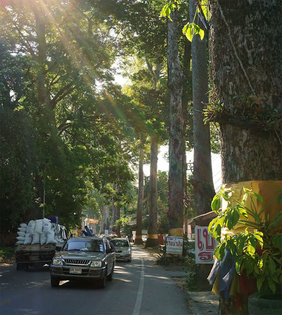
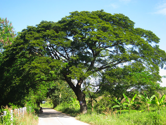
Yang na trees lining the busy Chiang Mai-Lamphun Road (Nong Hoi)
The tree mapping project I touched on in that interview is what I'm working on lately. Nut and I moved to Nong Hoi last spring. Our new neighborhood is on the south side of Chiang Mai and after discovering the good coffee shops and restaurants nearby, we've come to really like it. I have been fascinated by the magnificent and stately Yang na trees lining the Chiang Mai-Lamphun Highway through Nong Hoi (Route 106) since I first saw them several years ago. Their scientific name is Dipterocarpus alatus and they're related to rubber trees. Thais call them "ton yang na" (ton = tree). These splendid trees have an interesting history. They were planted in 1882 by order of King Rama V when the Chiang Mai-Lamphun road was but an ox cart. Residents living along the track were delegated to care for them by supplying water and fertilizer. You can read more about how they came to be in this short article. The shade they provide on the now very busy thoroughfare is wonderfully cool and reminds me of the elm tree "tunnels" that once adorned most of the streets in my hometown of Buffalo, NY. Buffalo's elm trees are long gone, killed by the Dutch Elm Disease that ravaged the U.S. back in the 70s. These trees might disappear someday as well but for a different reason: traffic and pavement have stifled their growth and made them vulnerable to disease. Dipterocarpus alatus is now considered an endangered species in its original habitat (see this Wikipedia article), and many of the Nong Hoi trees are either gone or in poor health. You can tell by the ribbons of gold cloth tied around each trunk that the Thai people revere them. Yet despite that concern pavement continues to encroach and their overall health continues to decline.

Yang na trees - morning - Nong Hoi
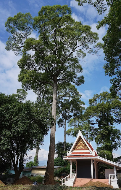
A healthy, open grown Yang na - Nong Hoi

I'm planning to enter data for each local Yang na tree into OSM. I will locate them positionally by using a combination of GPS data and spatial observations from the ground. Almost every tree has a tag with a number on it. I'm not sure which Thai government agency maintains these records, or if any do, but I'll enter that number in the ref tag when available. I measured the height of some of the ones closest to my home using an iPhone app called Theodolite which does the same thing as the theodolite instrument used by surveyors, which is to measure angles. It's not nearly as accurate as those precision instruments but is, as we say, "close enough for guv'mnt work" and just the ticket for my needs.

Theodolite (v5.0) screen on iPhone 5
In practice you can use simple trigonometry to calculate the height of the side of a right triangle given the length of one side and the angle between them. The trick is in measuring the angle. Theodolite makes that easy. I paced off a distance from the base of a tree and then sighted back toward it using the crosshair to mark A and B readings at its base and top; Theodolite then calculates a height. Since all these trees were planted at the same time most are roughly the same height, which is about 40-45 meters (~150 feet). It's not my goal to measure the height of each and every one of perhaps a hundred trees still standing but over the next few months maybe I'll get most of them positioned.

I've created a helper tool to make entering this information into OSM easier. JOSM is the most powerful editing program available for working with OSM and it's the one I use. It allows one to develop shortcuts called presets that facilitate entering data speedily, and consistently. Here's the one I'm using for the Yang na trees:

<item name="Tree: Yang na" type="node">
          <label text="Tag a Yang na tree node"/>
          <space />
          <key key="natural" value="tree" />
          <key key="leaf_type" value="broadleaved" />
          <key key="leaf_cycle" value="evergreen" />
          <key key="species" value="Dipterocarpus alatus" />
          <key key="species:en" value="Yang na" />
          <key key="species:th" value="ยางนา" />
          <key key="species:wikidata" value="Q140957" />
          <key key="wikipedia"  value="en:Dipterocarpus_alatus" />
          <space />
          <text key="height" text="Height (m)" default="" delete_if_empty="true"  />
          <text key="circumference" text="Trunk Circ. (m)" default="" delete_if_empty="true"  />
          <text key="height_trunk" text="Bole Height (m)" default="" delete_if_empty="true"  />
          <text key="diameter_crown" text="Crown Diam. (m)" default="" delete_if_empty="true"  />
          <text key="ref" text="Ref #" default="" delete_if_empty="true"  />
          <space />
          <text key="note" text="Note" default="" delete_if_empty="true"  />
          <space />
          <text key="name" text="Name" default="" delete_if_empty="true"  />
          <text key="name:en" text="Name:en" default="" delete_if_empty="true"  />
          <text key="name:th" text="Name:th" default="" delete_if_empty="true"  />
</item>

Using a preset makes it easy to remember exactly which tags are necessary to fully characterize the trees; it includes the scientific or Latin name, common names in both Thai and English along with the physical measurement data and saves me having to enter each tag manually. I've included tags with links to a Wikipedia article and the Wikidata entry. The code above produces the dialog box at the left (see below). After filling in the physical data and clicking Apply Preset, JOSM's Tags/Memberships Window (on the right) shows the relevant tags which are now ready to be saved and uploaded.

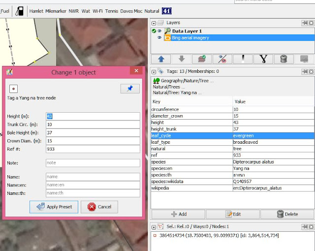
Applying the Yang na preset in JOSM
Another part of the project that is of primary importance to me is that I want to see "my trees" on a map. Someday OSM will be available in 3D and then the heights and crown diameters I'm entering will be used by rendering software to create pretty visual representations of them. But I don't want to wait for that to happen. The map you see on the main OSM page for this area has little icons for many common POIs (Points Of Interest): restaurants, hotels, bus stops, traffic signals, but doesn't show some of my favorite mappable items: trees, milestones, towers, and motorcycle fueling stations, to name only a few. (See my previous post Mapping in Thailand for more about my milestone fetish.)

That's why I began creating my own map icons that will display on my Garmin GPS and in Garmin's Basecamp program. For me, seeing the POIs I've entered on a map is one major payoff for the work I've done entering the data in the first place. I can also customise the colors and appearance of highways, woods and landuse polygons, and decide which POIs I want to see. I might not be interested in seeing hairdressing shops or veterinary offices visually but I definitely want to know if there is a nearby shop selling motorcycle fuel by the liter if I run low while riding out in the boonies. These small "bike petrol" shops are very common in rural Thailand where motorcycle travel is the norm.

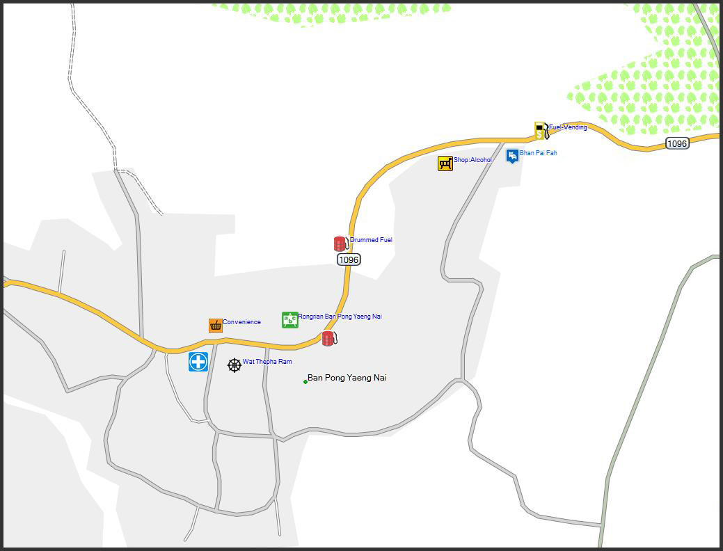
Fuel stations suitable for motorcycles. A "Drummed Fuel" station and a vending-machine fuel station

In fact, distinguishing a small shop selling fuel hand-pumped out of a large drum from normal full-service fuel stations was one of my main motivations for making my own maps and customizing them for my needs. To the OSM community both are "amenities", places to buy motor fuel. But personally I would not want to drive to a place that's hand pumping fuel by the liter if I need a tank of fuel for an SUV. I designed a unique icon for my GPS that enables me to tell at a glance which type of fuel station it is.

Another type of fuel station that's become increasingly common in rural Thailand are vending machines that accept paper currency in exchange for a metered quantity of fuel. I'm betting these shops will eventually replace the drummed fuel shops. I made an icon for those too, one of which is visible at upper right in the above Garmin Basecamp screenshot.

Getting back to trees, I've designed some icons to represent them as well. They need tweaking but they'll do for now. My plan is to use several different sized icons to represent trees that are especially broad or tall. Tests can be made during the map compilation process to determine sizes just as species is determined now. Another favorite tree, common here and appreciated because of the shade its huge leafy crown offers, is the Rain tree. Its scientific name is Albizia saman. Thais call it Ton Chamcha (ฉำฉา). This tree has a shape something like an umbrella and they are literally everywhere. I have a preset similar to the one for Yang na that applies a set of tags specific to this tree. I also have presets for teak (Thai: ton sak) and Bodhi or Buddha trees (Thai: ton pho), both are fairly common and both have special significance in SE Asia.

Chamcha tree
Below is a screenshot of an area in my neighborhood where Yang na trees line the Chiang Mai-Lamphun Road. This image is also taken from the Garmin Basecamp program and displays almost identically on the screen of my Garmin Montana GPS receiver mounted on my motorcycle handlebar.

Garmin Montana Screenshot Chiangmai-Lamphun Road - Nong Hoi
I add this last photo just to show that not all trees in my neighborhood are big or magnificent. Here is a shot of the little papaya tree that was only a stick when we moved here last March. In just 9 months it gained substantial height and its trunk is about 5" in diameter. As you can see it also has fruit almost ready for harvest. Nut's excited because she loves papaya and to get them for free is extra special.

Our papaya tree

Stay tuned and thanks for reading.


September 1, 2017: An effort to preserve and protect these wonderful trees is underway. The following short article appeared in Chiang Mai City News today:

Local villagers along the Old Chiang Mai-Lamphun Road are trying to save the century-old yang na trees as they are becoming more and more unhealthy from lack of air and nutrition.
According to Bunchong Somboonchai, head of a tree doctor volunteer group, said that there are about 900 yang na trees along the road and about 340 of them are in critical condition, being strangled by the concrete road, smothered by fumes of heavy traffic and generally living in a bad environment.
On August 30th, locals from A. Saraphi and volunteers gathered at Wat Koo Sua to implement a method invented by Maejo University, with support from Chiang Mai Provincial Office of Natural Resources and Environment. They delivered food and air through perforated PVC pipes filled with fertiliser were used and buried about two metres from the tree’s roots.
Bunchong added that it would take about two years for each tree to recover and to sustainably preserve these historic trees the whole community has to be involved and learn more about how to care for them.

Extras:
I was reading the OSM blog today, Christmas Day, and it contained a note concerning node #1, that is, the OSM object with an id of 1. It turns out that this particular node happens to mark a tree, and in addition that tree happens to grow in Passau, Germany, a town I visited a couple of years ago. It was my debarkation point for a 6-day bicycle trip along the Danube. How's that for coincidence?

The tree is located here: (48.566985, 13.4465242)

Monday, August 31, 2015

Alaska — Summer of 2015

For me another Alaskan summer has come and gone already. As usual I'm struggling with feelings both sad and glad. It was a fine summer especially because I bought an old but well cared for 1988 Winnebago in which I have been living since mid June. That means my usual uncertainty about where I'll be staying won't come into play next spring — I now have a place of my own. I found it on Craigslist and drove to Palmer to pick it up. The owner was asking 6500 bucks for it and explained that it had been well taken care of. It had even been recently waxed, top to bottom. He mentioned the fact that others were in line to see it but I only needed a brief look before making the decision; I knew in an instant that it was going to make the perfect summer home. While 27 footers are fairly common and are roomier than this 21 footer, I wanted something that would fit into a standard parking space and that was easier to drive than those bigger motorhomes. This one has all the basics: kitchen, furnace, toilet, hot & cold running water, even a flat screen TV and a comfy 3/4 bed that can be left fully open without blocking the entryway. The few weeks I spent in it were terrific — I enjoyed them thoroughly.

I came to Alaska back in 1983 in a Ford Econoline van my then partner KJ and I drove all the way from New England. The journey we embarked upon in November of 1982 was a long and circuitous one that took us first to Florida and Mexico before finally turning north toward Alaska. I completely enjoyed traveling and living in that van and had so many adventures and travels in it after settling in Homer that I've missed it a lot over the years. Although the Winnie's accommodations are quite modest by today's standards, they beat hell out of the Econoline and it's been a hoot living in it. I set her up behind my old office in downtown Homer so I have electricity, wi-fi, shower and toilet facilities, and my commute to work has been reduced from 5 miles to a just few steps. I will probably come earlier and stay later next summer now that housing is no longer a concern.

My Winnie at Quartz Creek
The Winnie's kitchen
I made a few trips north to look at motorhomes as well as two round trips to Anchorage with my son Tuli and grandson Harper. The Sterling and Seward Highways run through some of the prettiest country in the world and I relished it in the special way that someone who has hiked and fished in so many memorable places along the way can do. Below is Watson Lake where my good buddy Kirk and I went ice fishing many years ago. I drove that same Ford van out onto the ice where we used it for a windbreaker and portable kitchen. We had a chain saw along and like true Alaskans cut deadwood for a bonfire that kept us warm as we fished and after fortifying ourselves with a few shots of whiskey, cheerful too. One summer my old friend Jimmy Wiles and I caught a couple of Kenai River red salmon from my canoe. One of those fish dragged us all the way to the opposite end of the lake before we got it into the boat.

Watson Lake on a cloudy afternoon
With the glaring exception of the 4th of July weekend, which must have been a total bummer for countless Anchorage vacationers, it was a pretty fine summer weather-wise. The Homer area and Kachemak Bay region are photogenic and offer the photographer plenty to choose from. Here are a few shots from around downtown Homer.

Beluga Lake - 4th of July evening
Beluga Slough Trail
View from Mariner Park
View from Small Potatoes Sawmill
Small Potatoes' V-W powered Mobile Dimensions sawmill
As always I spent a good deal of time visiting with friends. There were cookouts and dinners, hikes and parties. A motorcycling buddy who, along with Al and DC, I traveled with during my first season in Thailand, Vancouver Andy, drove his new Honda CB500X to Homer from Vancouver, BC, in just three days. He hung around Homer for about a week and his presence was a good excuse to get the whole Thailand-Homer crew together for a dinner at Kiwi John's one night.
The Thailand Expats group, Homer Chapter
(L to R) Donnie, Albie, Walt, Vancouver Andy, Al, me, DC
My son Tuli and grandson Harper made an appearance again this year. After I picked them up at the Anchorage airport we camped overnight in a little pull off on the Hope Highway just a few miles from Hope. Tuli and I had spent a few very memorable days at the Porcupine Campground when he was a youngster and I was hoping to recapture that in some small way. Camping in Alaska is open on any public land and Alaska is chock full of public land. One can pull over and stay pretty much wherever you like. We had planned to stay at Porcupine but we found someplace better before we got there. The Hope Highway offers numerous places to free camp but his one was especially fine and we had it all to ourselves.


As luck would have it the pinks were indeed running. Resurrection Creek flows right through the little town of Hope and for a couple of weeks in July schools of pink salmon move upstream to their spawning beds. There were a few people
fishing but none of them had any fish landed. I chatted with a few of them trying to decide if it was worth digging out my boots and other gear. Two fellows told me fish had been caught earlier that morning and that it might be a good idea to make a few casts to see what might happen. The tide was rising and that often brings fish into the streams so I went back to the Winnie and grabbed my stuff. I had forgotten to pack my good lures and had with me only one old Mepps spinner in #2 size, which I figured was about right for this shallow stream. The spinner had a multicolored blade and its treble hooks were rusted from a long ago dunking in salt water but seeing as all the other lures I had were too big for such fast water I decided to try my luck with that one. I made a few practice casts until I was confident I could plunk the little spinner into the head of a long riffle at the far edge of the stream.

After a few casts, wham! A solid strike. I loosened the drag on my reel and gradually worked the fish to the side of the stream letting it run and pulling it back, enjoying each run. Then before it could work its way off the hook I quickly hauled it onto the shore. Now, most people will tell you that pink salmon are the poorest of the salmon species. They're small, not loaded with oil like reds and kings (sockeyes and chinooks for you southerners) and are less flavorful as a result. And that is true, to a point. They are a good fighter though and remind me of silver salmon (coho), which is one of the fightingest fish you'll ever come across. And too, a pink salmon taken just after it leaves salt water is a good eating fish that can hold its own on anyone's menu. A few more casts brought another pink to the shore. I cleaned them in the clear cold water, gave away the eggs they were carrying to fishermen who would later use them as bait, posed for a couple of photos with Harper, and off we went for pie and coffee at the well known Discovery Cafe in downtown Hope.

Resurrection Creek pinks

"Sprucehurst" 1989-1995
Not only did we have two fine fish dinners in store for us but I had relived a cherished memory that has occupied a special place in my heart for many years; the memory of living in Alaska when I was raising Tuli in a small cabin with wood heat and no running water. I'd return to those days in a heartbeat if it were possible.


A few days later we drove the Winnie north again to Cooper Landing for some rafting on the Kenai River with the Haggerty boys, Max and Lance, two of Tuli's lifelong best friends, and some other Homer folks. We all did a short float from Cooper Landing to the Russian River Ferry, and then the next day the group rafted from there down to Skilak Lake. Harper and I passed on that section and instead hiked to the Russian River Falls. The little guy hiked almost 6 miles that day, an impressive feat for a 6-year old city slicker!

The rafting party — Tuli's the tallest, Harper the shortest

Harper tries out Lance's pack raft
Lance Haggerty

Max Haggerty
On the Russian River trail
At Russian River Falls
Soon after that it was time to drop the boys off in Anchorage for their flight back to Eugene and for me to winterize the Winnie and pack my own bags for the annual trek to Thailand. I spent my last full day in Homer at Doug's daughter Maddie's wedding. It was a perfect end to another beautiful Alaskan summer.

The Explorer at my favorite Quartz Creek rest stop